Bill has been wanting to get to the Demilitarized Zone since he has been in South Korea, so I purchased tours through the USO. For those who don't know what the DMZ actually is, it is the area about 1 mile above and below the line dividing the North from the South. The armistice agreement at the end of the war defines what types of weapons and how many troops may be in the DMZ and Joint Security Area (JSA). The UN and the Koreans of both sides maintain the JSA. Although soldiers are obviously allowed in the DMZ, they must not cross the Demarcation Line (DML; isn't the military lovely with all their acronyms?) into the opposing country.
As you may see, all of this is serious business, and as such, prior to the tour, we were instructed as to what we could and could NOT wear and how we should conduct our manners. My husband can be quite the kidder and jokester, so I had to ask him to rein it in. All he wanted was his picture in North Korea, he said, and to dance with the North's guards. Great, I can get his picture dancing all the way to the work camp.
Instead of that, I got his picture in the DMZ sign. For all its seriousness, this is a big tourist attraction for Koreans and foreigners.
This monument recognizes the desire for reunification in the south. Reunification as the SOUTH defines it, since the North's definition is far different.
Prior to our tour of the Third Tunnel and the JSA, we had to have a briefing on the history of the area. Between the years of 1953 and 1999, Northern hostilities have killed 500 South Korean soldiers and 50 U.S. soldiers, so violence is not unheard of here.
There are also four tunnels that have been discovered traversing the DMZ from the North into the South, in an attempt for the North to gain secreted access to southern areas without going through the DMZ.
It is hard to see, but on the slide above, the DMZ is between the solid lines and the JSA is on the center line down the middle of the DMZ. The slide below is the Military Armistice Commission Headquarters Area, and the JSA is the circle on the yellow line, left of center of the slide. This is the area we toured. Yes, we had permission to photograph the slide show:)

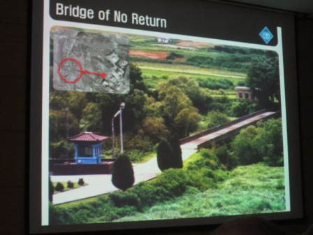
This bridge connects the North to the South. Trades of people occurred here, Northern prisoners for Southern prisoners, and once crossed, you could never go back if you survived the crossing, hence the Bridge of No Return. Because no development is allowed here, nature has taken over, and it is quite a beautiful area now. The slide below is an actual picture of I think 7 U.S. soldiers and some south Koreans who went to trim some branches from a tree very close to the Demarcation Line. The branches blocked the view of a North Korean observation tour by its closest South Korean counterpart. Upon the group's arrival, several North Korean guards approached, and a serious battle ensued where two U.S. officers were killed by a North Korean guard with an axe. Several other U.S. and R.O.K soldiers were wounded. Afterward an entire division with tanks was moved into the area, and the tree was cut down. A marker lies in its place to remember the victims. The war isn't over to many of these people, North and South.

In 1984 a citizen of the Soviet Union who was in North Korea on government business defected to the South through the JSA. Northern guards attempted to kill the defector, but Southern and U.S. soldiers returned fire and rescued him.

My apologies if this is sounding like a history lesson, but it was eye
opening to me that there are very recent (even more so than this; check
out Wikipedia for more) incidents between the North and the South.
Also in the southern part of the DMZ, a railway station was built. The North had agreed to allow a railway to be built through its part of the peninsula in order for a transeurasian (crossing Asia into Europe) railroad to be completed, allowing travel from Spain through Europe and Russia into the entire Korean Peninsula. Unfortunately, North Korea reneged on this agreement, and its portion of the railway was never completed. Dorasan is the last station in the south and is staffed and operational, carrying mostly supplies to the industrial zone South Korea runs in North Korea (that is another story but basically South Korean companies were allowed to put plants in North Korea and use their labor for an economic boost in the North; plant managers, about 1000 South Koreans, travel to North Korea every day to work there).
Above, Pyeongyang, North Korea, is the next stop. Below, the red line shows the railway through Russia into Europe. The blue line below is the Chinese connection.
Above is the wooded area we drove through to get to the JSA. It was cold. Below is North Korea from a South Korean viewpoint.
Below is one of the observation towers for the South. Land beyond that is North Korea.
Above, the blue buildings are the 'temporary' conference rooms built for peace talks. They are still used for discussions between the interested parties. These buildings cross the DML, so half of each is in the South and half is in the North. Below is a zoomed picture of the North Korean guard watching the tourists. He is on the steps of the large white building behind the blue ones. We were told there are also people inside the building watching us, and we were encouraged to point our cameras directly at them.
Here we are in North Korea with two R.O.K. (Republic of Korea, aka the South) soldiers inside protecting us (along with several outside and the U.S. tour guides and all that other stuff). Bill was very happy to be there, but he would have liked a stamp on his passport.
R.O.K. soldiers are no nonsense kinds of people. They face the North as long as there are people in the temporary buildings. They seem ready for whatever they may face.
Above and below are photographs of Peace Village in North Korea. It is a fake according to the South, occupied only when the North wants it to be. The buildings have lighting in the top only and no floors, so the windows will all look lit. The flagpole above was erected in response to a South Korean flagpole. The North had to have a taller one.
It was hazy that day as it often is here, but we were able to see a good bit of the North.
Above is a sign outside the Third Tunnel. We could not take pictures inside. We walked down into the tunnel up to the first concrete barrier placed by the South. It is 240 feet down and about a mile long. It is supposedly about 5'10" tall, but we had to wear hard hats, and I was glad. I knocked my hat several times on the reinforcement bars they had on the ceiling. Several times I had to bend over. Coming out was the hard part, almost straight up for 240 feet. There were rest station seats along the way, but we just trudged along. Several parents were literally dragging their children back up. Claustrophobics would not do well here. These tunnels were built by the North using dynamite, setting off the charges during war game exercises designed to cover the noise.
The coolest thing to me about the DMZ is its wildlife. Because this 2 mile wide area across the entire peninsula has not been touched, many rare species now exist here, and several groups keep an inventory of the wildlife. Rare cranes and big cats have been seen here along with numerous other birds and mammals. Our tour guide said sometimes mines will explode and upon investigation, wild boar are found to have tripped them. The mines have a weight sensitivity, and the deer are too small to set them off. Ted Turner pledged money to keep the area as a protected nature preserve when peace was truly reached. I hope one day this happens for the Korean people.


No comments:
Post a Comment